Selsey Photo Archive Project

The Selsey Photo Archive Project is a community driven project put together by the Manhood Wildlife & Heritage Group. The project was created using funding provided by the National Lottery Heritage Fund, and supported by Selsey Town Council.
It's aim is to make images of the town’s past available to a wide audience and encourage people to celebrate and engage with Selsey’s unique history.
Follow this link to see the images and stories in the Selsey Photo Archive
Marl Pits
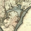
The Manhood Peninsula was a source of marl until the late 18th century, and marl found in Selsey was considered some of the best available. Marl has been defined as a pit from which marl, a mixture of clay and carbonate of lime, is excavated. Marl was commonly used as a fertilizer and marl pits were at one time... Read More»
1950's Selsey Sea Defences
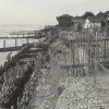
Sea defences have been required in the Manhood Peninsula for many years. A great deal of work was needed following a particularly bad storm in December 1951 which wrecked houses along the Selsey sea front, and led to their subsequent demolition. Following is a gallery of images courtesy of Royal Haskoning, the Coastal Engineering Consultant for Chichester District, showing the coastline and sea defences evolve... Read More»
Archaeology at Medmerry
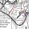
Medmerry, the country's first and largest open coast managed re-alignment scheme, is located south of Chichester. The site is managed by the RSPB together with Pagham Harbour, however the scheme itself was built by the Environment Agency as a flood defence work for Selsey and the Manhood peninsula. During the build a great deal of important archaeology was discovered that rewrote... Read More»