Traffic Hot Spots

In mid summer 2025 a meeting was held in Sidlesham to identify traffic accident and incident hot spots on the Manhood Peninsula, and anything else affecting the peninsula roads. All parishes on the Manhood Peninsula took part. The meeting also included other local groups interested in green travel, walking, horse riding and cycling who contributed their observations on potential accident sites.
The meeting arose out of previous discussions with WSCC Highways, during which it was suggested that GLaM develop a project including all the concerns about roads within which individual projects could be put forward for funding. The overall project framework would be intended to provide the rationale and evidence for smaller individual projects, which overall, would seek to address the Hot Spot issues raised.
The traffic hots spots identified were complied into a map and report, both of which can be downloaded below:
The GIS map can be found as a layer on CDC’s website:
http://mydistrict.chichester.gov.uk/
Here is some help to find the right map layer:
- Click on My Maps
- Click on Transport
- Tick on Manhood Traffic Problem Hotspots
- Tick on Manhood Traffic Problem Roads
The map will also be on Parish Online. The link will be circulated once available.
Solar Boat
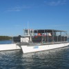
There are many environmental benefits to be found when using an electrically driven Solar Powered catamaran as opposed to more conventional fuel driven vessels: · Silent running – therefore no disturbance to birds, animals or humans · No exhaust emissions – therefore no CO2 contribution to greenhouse gases · The twin hull configuration contributes two major benefits; tremendous stability and no wash.... Read More»
Restoring the Record and the Definitive Map
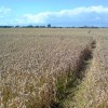
Numerous paths, tracks and lanes of ancient origin exist in this country. In 1949, the National Parks and Access to the Countryside Act established nationwide Definitive Maps of rights of way so people would know for certain where they could or could not legally walk or ride across other people’s land. It was the start of recording rights of... Read More»
Circular Cycle Routes
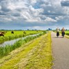
A leaflet has been created by the Selsey Cycle Network, which details the circular cycle routes that go around the Manhood Peninsula. The cycle routes are mainly on minor or traffic free roads and provide access to Chichester and Pagham harbours. They will also take you round the edge of the new nature reserve created as part of the... Read More»