Archaeology at Medmerry

Medmerry, the country's first and largest open coast managed re-alignment scheme, is located south of Chichester. The site is managed by the RSPB together with Pagham Harbour, however the scheme itself was built by the Environment Agency as a flood defence work for Selsey and the Manhood peninsula. During the build a great deal of important archaeology was discovered that rewrote the history books on coastal settlement in the pre-historic past. Here is the story behind the archaeology and the finds. Read the following article and follow this link to find out more about the archaeology finds at Medmerry:
The clay needed to build Medmerry’s new flood banks was dug from large shallow pits within the scheme, which provided a wonderful opportunity to look for archaeology. Archaeology South-East (ASE), from University College London, undertook the fieldwork and discovered some amazing finds.
Later Prehistoric (c. 4000 BC – 45 AD) Neolithic (c. 4000 - 2500 BC): The Neolithic represents a revolution in the way in which people lived in Britain with an abandonment of the previous hunter/gather way of life for one linked to domestic animals and farming. In Sussex we have some of the earliest British Neolithic monuments (such as the Flint Mines at Cissbury Ring, Findon and Causewayed Enclosures at the Trundle, near Chichester) but we lack information relating to Neolithic people's daily lives and the impact they had on their environment. Any evidence relating to this period is therefore extremely rare.
Several small assemblages of Early Neolithic pottery were recovered from archaeological features. These finds doubled the number of known features of this date from non-monumental sites on the Sussex Coastal Plain and is an important development in understanding the nature of the Sussex Neolithic.
Bronze Age (2500-750 BC): The Bronze Age marks the, "first golden or international age", with ideas, trade, goods and technology travelling across Europe. This was marked by monuments such as Stonehenge and an increasing pressure on the most valued and productive land. Funerary practises altered through the period with later Bronze Age burials becoming more associated with the working landscape of the living rather than within Barrow monuments on more marginal land. Environmental change is suspected to have significantly affected communities during this period and a greater risk of flooding may have precipitated an abandonment of the Sussex Coastal Plain at the end of the period.
Numerous features from this period were uncovered at Medmerry including: three large and two small circular houses/structures, enclosures and field systems, water management features, 'burnt' mounds, a cremation cemetery. It would appear that a large area of Bronze Age landscape was preserved at Medmerry under alluvial and storm beach deposits and the site also preserved wooden structures, such as a section of wattle work recorded at the base of a Bronze Age well, which has been C14 dated to around 1,100 BC. Other features were dated by finds of Bronze Age pottery, some of which was decorated.
Iron Age (750 BC TO AD 43) and Roman (43 - 410 AD): The Iron Age and early Roman remains were notable by their absence, with only one ditch containing a single sherd of Iron Age pottery. This may suggest that the lower lying areas of the site were regularly flooded during this period making them unsuitable for settlement and other uses which would leave an archaeological signature. The area could still have been used as pasture and settlement in these periods, most likely lying to the north on higher ground.
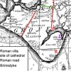
A large amount of mid Roman high status pottery, a cremation with ancillary vessels and a large mill stone recovered during the excavation of the V-ditch, suggest that there may have been a high status settlement near to the site during the later Roman period.
Medieval (AD 1066-1485): Several features including substantial ditches and wells suggest a differing pattern of settlement during the medieval period around Easton and Ham farms. One of the wells was chalk lined and a timber ring template in very good condition was recovered from the base. The quality of construction suggests that the well was for domestic use but historic maps dating back to the mid-18th century do not show settlement in this area.
Post - Medieval (post 1485): A series of enclosure and drainage ditches were recorded across the site, most of which appear to confirm the presence of features recorded in the mid-18th century map produced by Yeakell and Gardner.
WWII: The site contained several important WWII components. Including, a series of defences put in place to defend the south coast from German invasion, as evidenced on site by a series of pill boxes.
Prior to the D-day landings the site was also developed as an air to ground gunnery range, training pilots ahead of military action in Europe. The gunnery range continued in use into the cold war period and some of the first jet fighters were tested on the site.
Erratics: Three erratics or large boulders were found at Medmerry. The boulders were carried here by floating drift ice or icebergs at the onset of an Ice Age, possibly around 200,000 years ago. They were stranded at a time of higher sea levels when the climate was deteriorating but could have been moved as a consequence of events causing coastal erosion or changing sea levels.
The three erratics found are of different rock types, which is quite common. They are an important find because they represent tangible evidence of climatic changes and our geological past. There is a lot to still understand about these boulders, which is why it is so important to preserve them and understand the context in which they are found. One of them is on display outside Pagham Harbour visitor and education centre.
The archaeological project has produced academic and popular publications and the archive of artefacts and data will be submitted to Chichester Museum.
Maritime History
For most of its history, Sussex has been an agricultural county. The Chichester area, with the fertile coastal plain for arable and the Downs for sheep and cattle grazing, has long been one of the richest in agricultural terms. Just as the medieval sea trades were based on wool, Chichester Harbour’s sea trade from the 17th to the early... Read More»
Marl Pits
The Manhood Peninsula was a source of marl until the late 18th century, and marl found in Selsey was considered some of the best available. Marl has been defined as a pit from which marl, a mixture of clay and carbonate of lime, is excavated. Marl was commonly used as a fertilizer and marl pits were at one time... Read More»
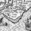
Archaeology in the Manhood Peninsula
The Manhood Peninsula is a large peninsula of land to the south of Chichester. The name is thought to derive from the Anglo-Saxon maene-wudu meaning ‘common wood’. It has long been known as a particularly attractive area because of its fertile soils and its rich, varied natural resources. This popularity is borne out by concentrations of archaeological sites and... Read More»