Sonde and Telemetry

CHASM is pleased to be working with the Environment Agency National Water Quality Instrumentation Service (NWQIS) and Meteor Communications. The aim is to measure water quality parameters along the coast of the Manhood Peninsula, south of Chichester West Sussex, and within Chichester Harbour. This is enabling us to look at some of the environmental factors such as turbidity and water quality that might be affecting crabs and lobsters, but also other biota including plants.
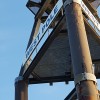
During summer 2020 sonde data loggers measured dissolved oxygen, salinity and turbidity in relation to ‘live’ weather events in Bracklesham Bay and Selsey The photograph at the top of this article shows a sonde and its sensors.
We have since expanded on the first year of work in Bracklesham Bay through the use of sonde and telemetry units on West Pole (located immediately outside Chichester Harbour) and in Fishbourne Channel outside Chichester Marina. This information is gathered by the sonde and relayed via a telemetry unit and satellite to the Environment Agency offices in Reading. The intention is to measure dissolved oxygen, salinity, turbidity and fDOM coming from the Solent, Chichester Harbour and the east coast of the Isle of Wight. These inputs are thought to work their way along the coast through Bracklesham Bay and Selsey, affecting many species on their journey.
For NWQIS this is a feasibility study into the effectiveness of equipment use in a harsh coastal environment. This type of work has not been previously undertaken by the EA on the open coast and the CHASM project is a useful vehicle with which to test its effectiveness.
The following links enable you to access the live and archive data at the various locations.
West Pole and Chichester Marina are both live links and show data gathered every 15 minutes. Currently data is not being collected at West Pole because we are reviewing the best way to anchor the sonde unit, but data gathered before 2026 is still available:
- https://telemetry-data.com/open?profile=WESTPOLEFINAL
- https://telemetry-data.com/open?profile=CHICHESTERMARINAFINAL
The sonde sites from 2021 and the Dell Quay data are archived information. There is no specific page on the Dell Quay sonde because it was only operational for a very limited period and didn't reveal much of interest:
- https://telemetry-data.com/open?profile=SONDESITES2021
- https://telemetry-data.com/open?profile=DELLQUAYFINAL
Using a telemetry unit and sonde is enabling us to observe real time data for periods of over a year. The length of time is key because it means seasonal and interannual variability can be recorded.
There have been a number of stages to this part of the project so far.
- During the summer of 2021 sonde data loggers were installed at three sites on the Manhood Peninsula coast - in Bracklesham Bay, outside Medmerry and outside Pagham Harbour.
- In spring 2022 a sonde and telemetry unit were installed on West Pole, Chichester Bar, just beyond the mouth of Chichester Harbour. Data collection stalled for several months following storm damage to both the sonde and telemetry units. Low tide and calm weather were needed in order to replace the units, but the weather didn't turn our way until April 2023. The new link was live until late autumn when storms again destroyed the equipment. Winter deployment has been unpredictable, and the data (when we could acquire it) didn't reveal much. It has therefore been decided to replace the West Pole units in spring 2024 and leave them in situ until late summer, but retrieve them before the weather deteriorates in Oct/Nov.
- In mid-summer 2022 a data logger was installed further up Chichester Harbour and gathered data for three months during the extreme heat of summer 2022 in the main Fishbourne channel outside Chichester Marina. The low oxygen findings were extreme and prompted the Environment Agency to install a sonde and telemetry unit to replaced the original data logger. The unit is currently acquiring live data.
- The 2024 CHASM Sediment Report report was produced by University of Southampton.
- Monitoring is ongoing at the Chichester Marina site but has been temporarily halted at West Pole while a more robust method of installing the sonde in the very challenging open coast environment is established.
Many thanks to NWQIS for agreeing to use the site as feasibility study. Follow this link to find out more about NWQIS, the National Water Quality Instrumentation Service
A huge 'thank you' also goes to the following organisations on the peninsula for their ongoing support, and for providing funding to enable the sonde monitoring elements of CHASM to make such good progress:
- West Wittering and East Wittering & Bracklesham Parish Councils
- F Glenister Woodger Trust
- Sussex Kelp Restoration Project
…and to Chichester Harbour Conservancy for doing the hard work of getting the units on West Pole and in Fishbourne Channel installed!
2022-2024 West Pole
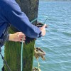
Shortly after Easter 2022 a real-time water quality monitor was deployed on the West Pole Beacon just outside the entrance to Chichester Harbour. The reason for monitoring this site is to help determine factors affecting crabs, lobsters and other marine life in the area. The site is a meeting point for a number of water bodies, including Chichester Harbour,... Continue Reading »
2022-2024 Itchenor Reach - Chichester Marina
During summer 2022 CHASM installed a sonde data logger on one of the wooden markers near Chichester Marina on Itchenor Reach. The aim was to complement the data being gathered by the sonde and telemetry unit on West Pole outside Chichester Harbour. The unit wasn’t able to capture real time data because it wasn't linked to a telemetry unit, but... Continue Reading »
2021 Three Sonde Sites
In May 2021 the NWQIS department of the Environment Agency kindly loaned the CHASM project an EXO2 Sonde data logger to measure a number of sea water parameters. The aim was to start finding out what is happening in the waters of Bracklesham Bay where the lobster decline was first noticed. To ensure the sonde units would stay in place... Continue Reading »
National Water Quality Instrumentation Service (NWQIS)
The National Water Quality Instrumentation Service (NWQIS) is responsible for testing, building, calibrating, deploying and maintaining multi-parameter water quality equipment across England. They offer both handhelds, used for spot sampling, and real-time monitors that can be deployed in situ and report live data via telemetry at a specified interval frequency. The data from these devices relates to the physical... Continue Reading »