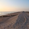
Medmerry

Most of the new paths have been open in their unfinished state this winter, and many people have taken the chance to try them out. Many people have been delighted, even in this condition. A temporary leaflet to help you find your way around Medmerry is available at the Visitor Centre in Sidlesham, and from Earnley car park gates.
Everyone is asked to respect the section of bank where there is no public access (either on top or alongside it), which runs from Ham Viewpoint northwards towards Wilson’s Farm. This has been designed as a refuge area, to help wildlife and the privacy of local residents. People found on this area will be escorted back to public areas.
Once the scheme is complete, the permissive equestrian access will be the 5-metre wide grass strip. For now, please use the access track landward of the bank for horse riding, but please remain at a walk to avoid damaging the surface. There is no equestrian access yet via Ham Lane, which is still subject to negotiation.
The Environment Agency’s contractors will be carrying out works across the reserve from early May until August. They will be creating the access track landward of the bank between Chainbridge Sluice and the beach, putting in a ‘V’ ditch at the bottom of the landward slope of the new banks to help keep the footpaths/cyclepaths dry, putting in drainage underneath the main footpath/cycleway where necessary, installing benches and signs, undertaking landscaping, raising the land level behind the Bunn Leisure viewpoint, ensuring the path surfaces are fit for visitors, finishing the gates and car parks; hopefully all to be completed by autumn!
Every effort will be made to keep access paths open during construction. There may be the need for occasional and temporary path closures, but every effort will be made to ensure they are well signed.
Get involved! Visitors are encouraged to help ensure that Medmerry is used appropriately and any antisocial behaviour is avoided. If you see something that is illegal taking place, then please call 999. If you see any other problem, please contact Pete Hughes, the RSPB Medmerry Senior Warden, on Medmerry@rspb.org.uk or 01243 641508. Do get in touch with Pete if you would like to volunteer at Medmerry - a range of tasks is available including talking to visitors, wildlife surveys and practical work.
Coastal Management
A large part of the Manhood Peninsula is less than 5m above sea level and at risk from flooding, both inland and coastal. It is likely that climate change will increase this risk, through rising sea levels, rising water tables and increased precipitation intensity. Drainage is an increasing problem on the peninsula as the existing ditches are proving inadequate... Read More»
Archaeology at Medmerry
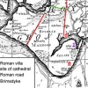
Medmerry, the country's first and largest open coast managed re-alignment scheme, is located south of Chichester. The site is managed by the RSPB together with Pagham Harbour, however the scheme itself was built by the Environment Agency as a flood defence work for Selsey and the Manhood peninsula. During the build a great deal of important archaeology was discovered that rewrote... Read More»
GLaM

GLaM aims to enhance the visitor experience and support sustainable transport measures on the coastal plain by capitalising on the footpaths and green links provided by the Medmerry Managed Re-alignment and other schemes. GLaM aims to further this by creating and improving more circular and green routes across the peninsula that will play their part in a Sustainable Transport... Read More»